
Irkutsk Region, 9.02.21 (IA Teleinform), - Specialists of the Protection of Protection conducted more than 20 routes passing through the territory of the Pribaikal National Park, and also prepared information about dangerous areas and recommendations for overcoming them.
According to the press service of "Reserve Protection", all these routes, in accordance with Evskm criteria (the Unified All-Russian Sports Classification of Routes) belong to non-projectic. Despite this, the plots of some of them run in the mountain and rocky area, in the zone of the surf during coastal foreings and so on, which represents a certain complexity and is associated with risk.
Hiking Route BBT-1 "p. Listvyanka - p. Bol. Holochetic "(55 km) takes place along the ridges and slopes of the Primorsky Range, the shore of Baikal and the river valleys, which flow into the lake; It is the southern plot of a large Baikal trail (P. Latvyanka - p. Buguldeka), one of the first tourist routes in the Baikal.
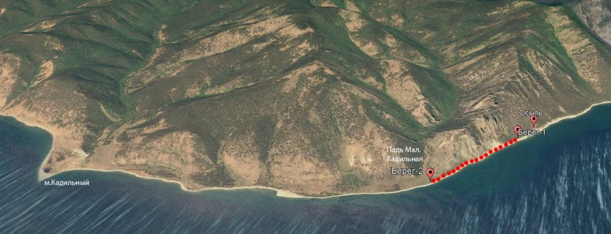
One of the dangerous sites near the Padi Small Cadyl - ignitions "N51 ° 56.901 'E105 ° 15.557. The trail passes above the fission. The length of a dangerous section of 50 meters. Recommendations: Use trekking sticks. Passing a plot, distanceing from each other at least 3 meters away. Equipment: The trail under the ozosity is strengthened with a wooden wall; Near a dangerous area is planned to install an information booth.
On the same route "Shore 1" ... ... "Shore 2" N51 ° 56.143 'E105 ° 15.421 ... ... n51 ° 56.757' E105 ° 15.547 - a dangerous area near the Paddy Small Cadyl; The route passes through the rocky beach in the surf area. The length of the plot is about 1 km. A coastal strip of a width of about 5 m passes between the coastline and oiled cliffs. Danger represents storm waves, wind, nondes from October to December, showering of a loose rock. Recommendations: Use trekking sticks. Pass the site is possible without stopping. Equipment: near a dangerous area is planned to install information stands. Exit to the coastal site from n. Large holochetic (the point of "shore 1") is equipped with a staircase descent.
Dangerous sites on the Tseychy Rock and near Cape SobolevThe next dangerous area of the BBT-1 route is near the Caeychi Rock: "Teaful 2" ... ... "Teaful 1" N51 ° 54.174 'E105 ° 09.825 ... ... N51 ° 54.441' E105 ° 10.239. The trail goes along the rocky coastal cliffs with "clamps". The length is 0.5 km. Hazards - "Prints" on the cliffs, a gusty wind, the collapse of the wreckage of rocks. Recommendations: Use trekking sticks. Passing a plot, distanceing from each other at least 3 meters away. Equipment: near a dangerous area installed information stands.
Another dangerous section of BTT-1 - near Cape Sobolev: "M.Sobolev 2" ... ... "M.Sobolev 1" N51 ° 53.889 'E105 ° 08.374 ... ... N51 ° 53.913' E105 ° 08.748. He passes along the rocky beach in the surround zone. The length of the plot is about 0.5 km. A coastline of about 2-5 m wide passes between the coastline and rocky cliffs. Hazards - storm waves, wind, land in October-December, collapse of the rocks of the rocks. Recommendations: Use trekking sticks. Pass the site, if possible, without stopping. With dangerous stormy weather, you can use a workaround (equestrian) route passing between the screen and Cape Sobolev, at a distance of 200-400 m from the coast. Equipment: near a dangerous area it is planned to install information stands indicating the occupancy on the bypass route.
Dangerous area between pores Sneakers and mediumAlso, there is a dangerous area between the paders of the pores and the average: a porch (2) ... ... Average (1) N51051.940 'E104O57.748 ... N51052.199' E104O58.469. The trail goes along the rocky coastal cliffs with "clamps". The length of about 1 km. Hazards - "Prints" on the cliffs, a gusty wind; From October to December and in April-May Snow nansos and nondes on the trail.
Recommendations: Use trekking sticks. Passing a plot, distanceing from each other at least 3 meters away. From November to December and in April you can use an alternative route "P. Listvyanka - Per. Hurricane - Pad Black ", a hazardous area; In the winter time (February-March) it is advisable to go through this site on Ice Baikal. Equipment: near a dangerous area it is planned to install an information booth.